Mapping accessibility and wellbeing
Can you imagine turning up for your the specialist health appointment and being turned away because you couldn’t physically get onto the examination table from your wheelchair?
Can you imagine being carried into your specialist appointment because the doorway was too narrow?
This is the reality of healthcare for many people with disabilities every day. Inability to access health services by people with spinal cord injury (SCI) translates into low levels of health service use and, not surprisingly, poor overall health. According to the World Health Organisation, people with SCI are 2 to 5 times more likely to die prematurely than the general population. Many of these early deaths are preventable, but require good access to healthcare. The Hopkins Centre (THC) Research Fellow, Dr Ali Lakhani, is working with affiliate partner Spinal Life Australia (SLA) to examine the spatial distribution of accessible health services and improve access for Queenslanders with SCI in the hope that we can reduce avoidable deaths and improve quality of life.
Prevention is definitely better than cure in the case of people with SCI who are managing the long-term impact of their condition on their physical health. If people with SCI are unable to access timely advice on treatment and prevention for pressure injuries, these injuries can quickly worsen, leading to hospitalisation. Similarly, respiratory and kidney health must be treated quickly or they will necessitate longer and more costly hospitalisation. This diverts resources away from other aspects of life that may result in better outcomes for the individual and family.
Accessibility audits are rarely conducted at health services and when conducted, they are often completed by people without lived experience of disability. The focus of these audits is often on compliance with national codes, but not on the more subtle aspects of access. It is also unclear where the accessible and inaccessible health services are located across Queensland. Without this information, people with disability and peak organisations like SLA are unable to advocate for improvements to the structural barriers that impact on health service access..
Using a geographical information system, our researchers are investigating the relationships between health service accessibility, utilisation, and the health and wellbeing of people with SCI. The study will also identify the aspects of health services that contribute to inaccessibility. For our partner SLA, the study will provide evidence to inform where to best direct their advocacy efforts to promote the development of accessible health services in Queensland.
Project leader, Dr Ali Lakhani from The Hopkins Centre is excited to be involved in this project because it has the potential to have such a positive impact on the lives of people with disability. ‘I greatly appreciate the opportunity to work with Spinal Life Australia on this important study. SLA members have all told me that so many areas in the community are not accessible, but the real urgency was to improve healthcare access. The members have been instrumental in designing this study & it will become a resource they can use in future.”
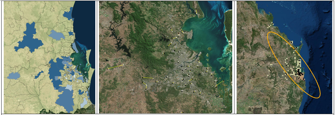
Figure 1: Examples of thematic maps that will be produced as a result of the spatial analysis study
The three maps above are based on preliminary findings from the spatial analysis study partnering with Spinal Life Australia. The thematic map on the left illustrates the perceived physical accessibility of general practitioner services according to participants with a spinal cord injury. Darker blue colours indicate regions where general practitioner services have been graded as having higher levels of physical accessibility, while lighter blue colours indicate regions where general practitioner services have been graded as having lower levels of physical accessibility. Subsequent analysis including the entire sample will clarify the perceived physical accessibility of a diverse set of primary, allied, and specialist health services.
The middle map illustrates the geographic dispersion of participants with spinal cord injury in relation to physiotherapists. Participants are represented by black triangles, while physiotherapists are represented by white circles. Yellow lines indicate the closest physiotherapist to each participant. Preliminary findings from a network analysis conclude that the average travel time (via car or private vehicle) to the closest physiptherapist is 4.23 minutes (maximum of 39.54 minutes) while the average travel distance is 3.15 kilometers (maximum of 28.95 kilometers). Subsequent analysis including the entire sample will clarify areas which have high proximate and low proximate availability to primary, allied and specialist health services.
The map on the right illustrates the geographic dispersion of participants with spinal cord injury in relation to allied health services. Participants are represented by black dots, while clusters of allied health services are represented by yellow and orange squares. Orange squares represent areas of significantly high levels of allied health services, while yellow squares represent areas where there are neither significantly high nor significantly low levels of allied health services. Preliminary findings conclude that approaching 70% of the sample are located within South-East Queensland (the area within the orange ellipse). Participants residing within the orange ellipse are generally located in areas with significantly high levels of allied health services, or areas where there are neither significantly high nor significantly low levels of services. Subsequent analysis will clarify underserviced areas.
If you’re interested in research that The Hopkins Centre is involved in or you’re keen to get involved or partner with the centre, contact us at hopkinscentre@griffith.edu.au